
The Dry Season Is Your Only Window
Simple, high-value road work you can do right now to keep sediment out of the creek — and why this particular autumn deserves your attention.
Sediment from erosion, as the Mendocino County RCD puts it, is the number one pollutant impairing North Coast streams — and rural roads are where much of it comes from. The fixes are not exotic. Most are a matter of shaping a road so water leaves it early, often, and gently, done while the ground is dry and the channels are empty.
That window is open now, and it closes sooner than the calendar says. Under the Rural Roads Order you must finish work underway at crossings, get erosion control down, and start nothing new once the seven-day forecast shows any of three things: five straight days with any chance of precipitation, three straight days at 30 percent or greater, or two straight days at 50 percent or greater. That first condition trips early. The forecast ends your season, not the date on the permit.
Mark your calendar:
The clock is running
April 1 – October 15: work window for rural road and crossing projects (NCRWQCB Rural Roads General Order R1-2024-0002). Slope protection on all disturbed ground in place by October 15.
June 15 – October 15: the only period you may work in the bed, bank, or channel of a stream under the cannabis general LSAA (14 CCR § 722) — which covers crossings and diversions on non-fish-bearing streams only. A Class I crossing needs an individual agreement with its own window. Note § 722 carries its own stop-work trigger: a 30 percent chance of rain in the 72-hour forecast.
November 15: winterization complete and temporary roads closed to vehicles (NCRWQCB cannabis program).
If You Are Grading this Summer, Lose the Outboard Berm
This is the highest-value thing most people can do with a machine, and the cheapest.
A well-built road sheds water off its outside edge in a thin sheet along its whole length. A berm — the ridge of loose material a blade throws to the outboard shoulder — defeats that. Water is trapped against it, turns, and runs down the road instead of off it, gathering volume and speed until it finds one low spot and cuts. What should have been sheet flow across fifty feet of duff becomes a gully in the tread or a blowout through the fill. A caption in the PWA/MCRCD Handbook for a reference photo (included below) describes the ideal: a well-built permanent road that "is slightly outsloped, has no outside berm, is occasionally rolled to provide continuous surface drainage and is rock surfaced for wet-weather traffic."
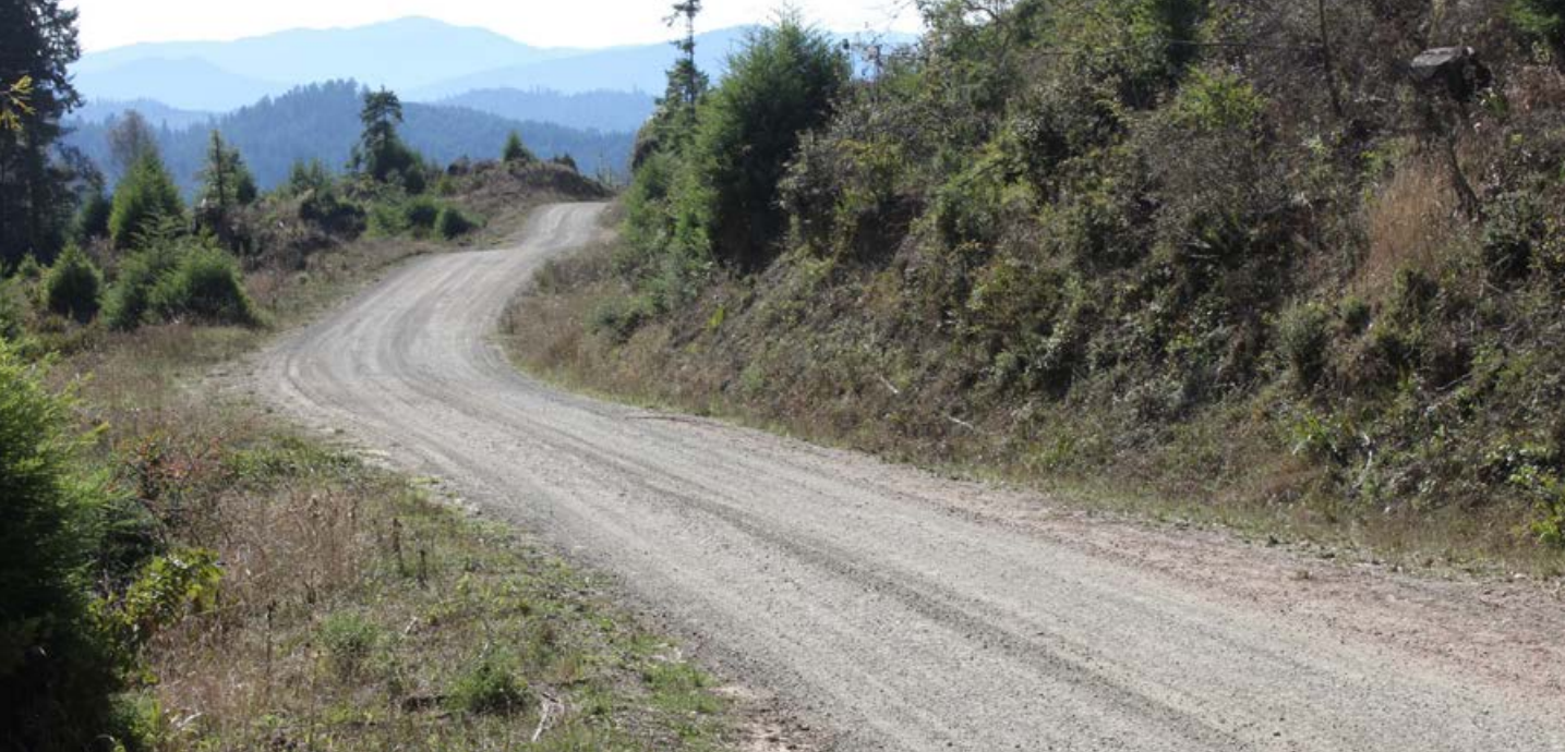
Photo Credit: PWA/MCRCD.
How much outslope? Do not chase one number — it depends on grade and on what you are building. PWA’s general outsloped road shape is 4–6 percent. Their rolling dip drawings are tighter: about 3–4 percent across the tread, and 2–4 percent on steep dip-drained segments with the outboard fill pitched at 4–8 percent. In slippery soils, inslope with a ditch instead, or add aggregate.
What if that edge is all that stands between you and a long drop? PWA answers it directly. On gentle segments, berms can simply be removed continuously, that is the default. It is on steep segments, where safety is a real concern, that you breach the berm instead: space the breaches every 30 to 100 feet, and you get drainage while keeping a semi-continuous berm for vehicle safety. The general rule is to keep the downhill side free of berm except where one is intentionally built to control water or traffic.
It is fast. PWA’s production rates put berm removal at roughly 1,000 feet per hour with a dozer, or 500 with an excavator. Put the dozer figure next to the alternatives and the case makes itself: outsloping a road with ditch fill runs 500 feet per hour, insloping or crowning about 300.
Put the spoil where it will stay. MCRCD is specific: above the high water mark, outside the 100-year floodplain, more than 200 feet from a waterbody. Avoid steep or eroding slopes, and cover the pile if you have no choice. And per PWA, do not use sidecast construction on slopes over about 55 percent. The resulting fillslope lands near the angle of repose, and that is how fill failures start.
Walk Every Culvert Now, While the Channel is Dry
An inspection you can do in boots in July is one you cannot do in a rain jacket in January. A dry channel is a gift: you can see the whole structure and pull debris and built-up material out without putting heavy equipment in flowing water, which MCRCD tells you not to do anyway.
At the inlet: Open and sound, or plugged with sticks and gravel? Pipe crushed or rusted through? Material sloughing off an over-steepened cutbank? A drop inlet can stop chronic plugging, and a trash rack set upstream handles floating debris.
At the outlet: The pipe must extend past the base of the road fill, or carry a downspout that does. A pipe dumping onto the fill face erodes your road every time it runs. Look for scour pools, undermining, or a gully forming below. Armor with rock or slash.
At the bottom: The best crossings sit at channel grade, inlet and outlet resting on or partly in the original streambed. A perched pipe is a fish passage problem and a scour problem at once.
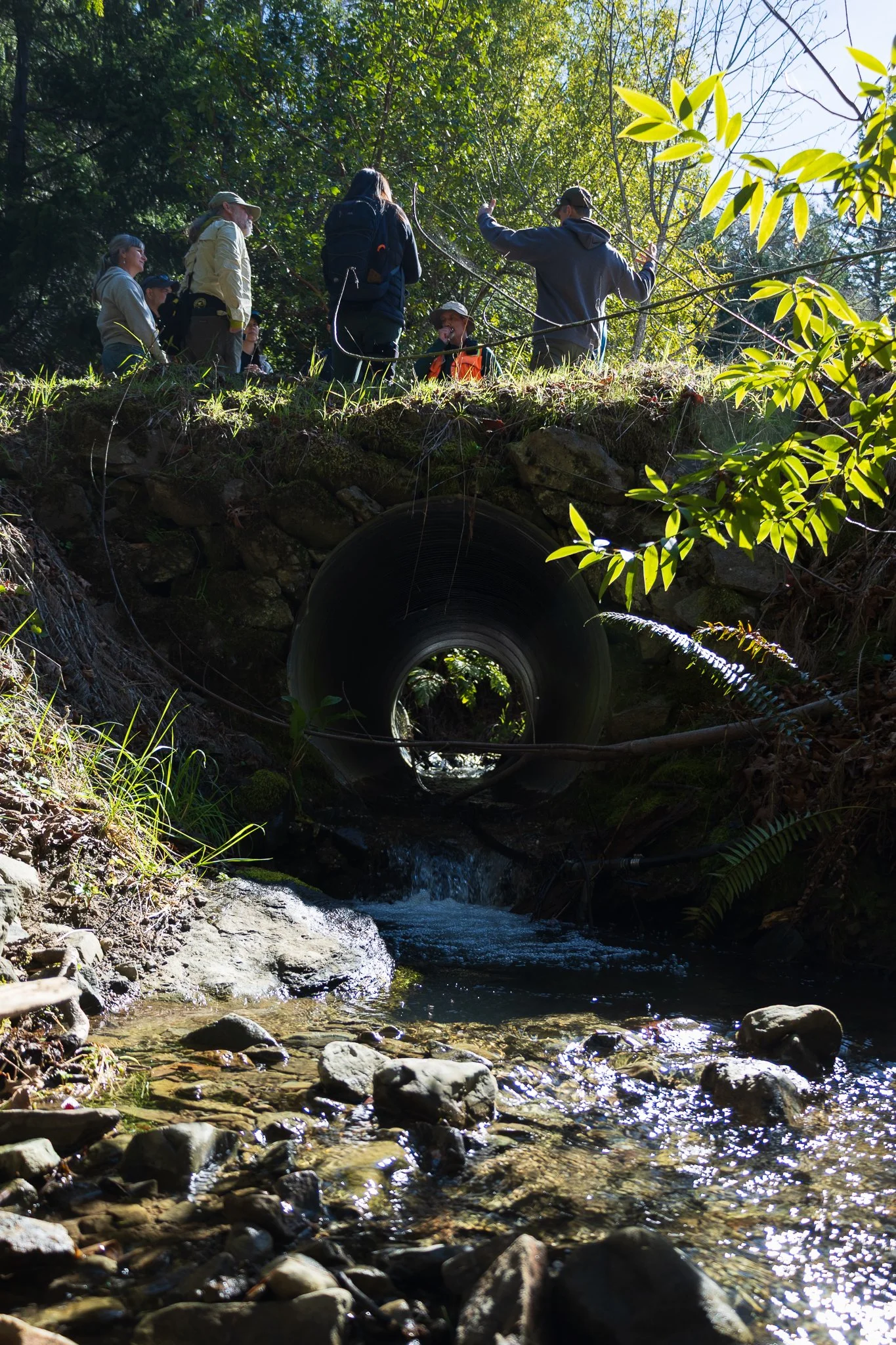
The one that saves the crossing: a critical dip
Install a critical dip at every culverted stream crossing. When the pipe plugs, and eventually one will, the dip returns overflow to its own channel instead of letting the stream capture the road and divert into a neighboring drainage. That is the difference between a washed-out crossing and a stream permanently rerouted.
Build it on the downhill side, extending from the cutbank to the outside edge of the road, filling the inboard ditch if present. Unlike rolling dips, critical dips are built perpendicular to the road on purpose, so flow goes straight back to the channel. PWA budgets about an hour of dozer time, plus a water truck.
Quick field test: stand on the road above the crossing and look both ways. If no road length drains back down to the site from either direction, the crossing has diversion potential and needs a dip.
Add Rolling Dips — And Stagger Them with Your Culverts
Dispersing road surface runoff is, in PWA’s words, "the best and most environmentally sound engineering practice" available to you, and outsloping with periodic rolling dips is how most people get there. Use dips rather than water bars wherever vehicles drive: a dip is built to be driven over, so traffic does not breach it. Build them at a 30 to 45 degree skew, cross-road grade at least 1 percent steeper than the road, carrying the reverse grade 10 to 20 feet. Spacing tightens as the road steepens. PWA notes that roads up to 8 to 12 percent grade can generally be outsloped with rolling dips and still handle most traffic; on steeper ground the answer is usually more outslope rather than more dips.
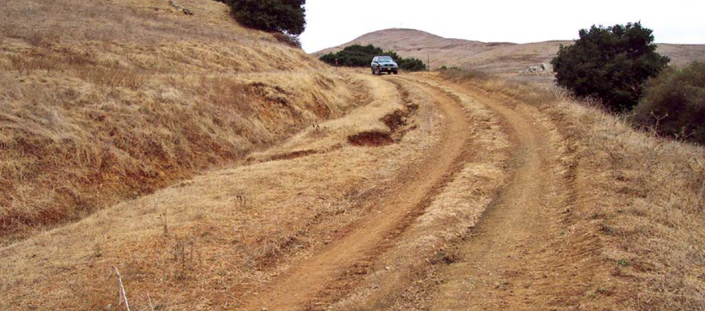
A rutted and gullied road before treatment.
Photo credit: PWA/MCRCD.
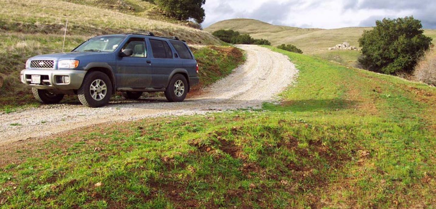
The same road outsloped with rolling dips.
Photo credit: PWA/MCRCD.
Where you use ditch relief culverts, stagger them with your dips so no single structure carries everything. They should be at least 18 inches in diameter and set at a 30 degree angle to the ditch. Watch the grade: PWA calls for a slope at least 2 to 4 percent steeper than the ditch leading into it, and notes that about a 10 percent culvert grade is usually self-cleaning. Steeper is better. Armor the outfall.
Go easy on ditches. Reshape them where they genuinely lack capacity, but do not grade a ditch that does not need it, you are only manufacturing loose sediment. In highly erodible soils, build a flat-bottom ditch, not a V.
Rock the Roads You Actually Use in the Wet
Rock the year-round roads only; no sense spending gravel on a road you will gate in November. Surfacing matters most where a road is hydrologically connected to a stream, because that is where road sediment becomes creek sediment. Chip-seal or pave well before the rains so oils can solidify, degrade, or volatilize rather than wash off in the first storm. MCRCD sets the goal plainly in two places: make your roads "hydrologically invisible by designing for dispersed runoff," and keep them disconnected from streams, never draining into a watercourse or onto unstable ground.
Finish the Season the Way You Want to Start the Winter
Cover bare ground. Seed and straw-mulch bare ground with delivery potential before any rain. MCRCD calls for two tons per acre — about 42 bales — until you cannot see soil. Use rice straw so you are not planting a weed problem.
Work dry. Soil moisture helps compaction, but do not start road construction before the ground has drained and dried.
Reshape existing dips and water bars. Fix the ones that have stopped functioning before adding new ones, and make sure no outflow discharges to a stream or onto an active landslide.
Retire what you do not use. Storm-proofing or decommissioning a road you do not need beats maintaining it forever. But do not put permanent barriers on a road you still have to inspect, blocking access blocks maintenance.
Call Your Road Association — This Month, Not in November
Almost every serious road failure here happens on a road several people depend on and no one entirely owns. A crossing is only as good as the worst culvert upstream of it, and drainage does not respect parcel lines. If you share a road, the most useful thing you can do this month is get the neighbors on a call.
The agenda is short: walk the road together and list the crossings with diversion potential; decide who buys rock and who rents the machine; pool a mobilization so one excavator does five parcels instead of five excavators doing one; pick the two or three structures that would do the most damage if they failed; and set a finish date well before October 15.
And About this Winter
NOAA’s Climate Prediction Center reported on July 9 that El Niño is strengthening, with a 97 percent chance it persists through early spring 2027 and an 81 percent chance of a very strong event during October–December, which would rank among the largest since 1950.
Be careful what you read into that. For weak and moderate El Niños, Northern California has essentially no precipitation signal, and CPC’s current outlook does not lean wet for our region. Very strong events have been a different animal: the three that Jan Null classes as very strong all ran above normal on the North Coast — 162 percent of average in 1982-83, 154 percent in 1997-98, and 111 percent in 2015-16. (The famous 2015-16 "bust" was Southern California’s, not ours; Eureka finished at 120 percent.) Two caveats. Null classifies by one index and CPC is now forecasting strength by another, so the historical set and the forecast are not speaking quite the same language. And as Null says of his own tables, this is a climatology of past events and should not be used as a forecast.
Nor should you assume a strong El Niño simply means more water. The research on back-to-back atmospheric river "families" is more interesting than that: the storm pattern that shows up most often in El Niño years is associated with lower average precipitation across California than its La Niña counterpart, but longer duration. Long duration on a saturated watershed is its own kind of problem.
The honest summary is that the seasonal total is not the thing to watch. Seasonal averages do not blow out crossings. One atmospheric river landing on a plugged culvert with no critical dip does. Treat the forecast as a reason to prepare, not a prediction to plan around. A road that is outsloped, unbermed, dipped, and disconnected from the creek is the right road in a dry winter too. This year only raises the cost of being wrong.
Your Deadlines at a Glance
| Date | What | Authority |
|---|---|---|
| Apr 1–Oct 15 | Rural road and crossing work window | NCRWQCB R1-2024-0002 |
| Jun 15–Oct 15 | In-channel work (cannabis LSAA) | 14 CCR § 722 |
| Oct 15 | Slope protection and bare streambank stabilization complete | NCRWQCB R1-2024-0002 |
| Nov 15 | Winterization complete; temporary roads closed to vehicles | NCRWQCB cannabis program |
| Mar 1 | Annual Monitoring Report due | NCRWQCB cannabis program |
Where to Go Deeper (All Free Resources)
Handbook for Forest, Ranch and Rural Roads (Weaver, Weppner & Hagans; PWA and Mendocino County RCD, 2015). The standard, and the source of most of the specs above. Free at pacificwatershed.com/roadshandbook, with a Spanish edition and a companion video. The North Coast Rural Roads Order requires conformance with its "Characteristics of Storm-Proofed Roads" — worth reading on its own.
Watershed BMPs for Cannabis Growers and Other Rural Gardeners (Mendocino County RCD, 2018): mcrcd.org/resources/cannabis-resources. Written for growers, adapted in part from the PWA Handbook.
Gravel Roads Construction and Maintenance Guide (FHWA-OTS-15-002): fhwa.dot.gov/construction/pubs/ots15002.pdf. The reference on surfacing, crown, aggregate quality, and blading.
And call us: 707-630-3144. If you are not sure whether a crossing has diversion potential, or you want another set of eyes on a road before you put a machine on it, that is what we are here for.